the american practical navigator chapt 04
the american practical navigator chapt 04
... Figure 403b The graduation of the border scale of the chartlet enables navigators to identify the largest scale chart for a location and to find a feature listed in the IndexGazetteer These graphics ... and other information A Web search can often find the textual information the navigator needs USING THE LIGHT LISTS 406 Light Lists The United States publishes two differen...
Ngày tải lên: 08/05/2016, 10:16
the american practical navigator chapt 01
... the altitudes of the Moon and the Sun or a star near the ecliptic and the angular distance between the Moon and the other body The zenith of the observer and the two celestial bodies formed the ... to half the difference between the two latitudes and takes the name of the place farthest from the equator Longitude (l, long.) is the angular distance between th...
Ngày tải lên: 08/05/2016, 10:16
the american practical navigator chapt 02
... differs from the corresponding astronomic latitude by the amount of the meridian component of the local deflection of the vertical The geodetic longitude is the angle between the plane of the geodetic ... divided by the cosine of the latitude The geodetic coordinates are used for mapping 17 The geocentric latitude is the angle at the center of the ellipsoid (us...
Ngày tải lên: 08/05/2016, 10:16
the american practical navigator chapt 03
... which the axis of the cone is in the equatorial plane, nor the oblique conic projection, in which the axis of the cone is oblique to the plane of the equator, is ordinarily used for navigation They ... two dates At the top center of the chart is the date of the first edition of the chart In the lower left corner of the chart is the current edition number and da...
Ngày tải lên: 08/05/2016, 10:16
the american practical navigator chapt 05
... line The higher rear light is placed behind the front light When the mariner sees the lights vertically in line, he is on the range line If the front light appears left of the rear light, the ... higher level where the light can be seen, and noting a star directly over the light The bearing of the star can then be obtained from the navigating bridge and the bearing...
Ngày tải lên: 08/05/2016, 10:16
the american practical navigator chapt 06
... with the strength of the surrounding field, the mass of metal, and the alignment of the metal in the field Since the intensity of the Earth’s magnetic field varies over the Earth’s surface, the ... in the sea, the apparent vertical axis is displaced, first to one side and then the other The vertical axis of the gyro tends to align itself with the apparent verti...
Ngày tải lên: 08/05/2016, 10:16
the american practical navigator chapt 07
... from the DR position in the direction of the set, with the length equal to the product of the drift and the number of hours since the last reset See Figure 707 From the 0900 DR position the navigator ... to the current, this text will follow the convention of referring to the offset as the set and drift The set is the direction from the DR to the fix Th...
Ngày tải lên: 08/05/2016, 10:16
the american practical navigator chapt 08
... directly affects the vessel’s SOA The thicker the weather, the more slowly the vessel must proceed Therefore, if heavy fog or rain is in the forecast, the navigator must allow more time for the transit ... all the navigator s recommendations and whether the navigator concurs with the actions of the conning officer Record all buoys passed, and the shift between d...
Ngày tải lên: 08/05/2016, 10:17
the american practical navigator chapt 09
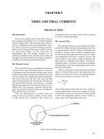
... Moon and Ms is the mass of the Sun, Re is the radius of the Earth and d is the distance to the Moon or Sun This explains why the tide-generating force of the Sun is only 46/100 of the tide-generating ... by the Earth’s gravitational attraction (Figure 903c) 131 Now consider the effect of the rotation of the Earth If the declination of the Moon is 0°, the bulges...
Ngày tải lên: 08/05/2016, 10:17
the american practical navigator chapt 10
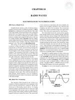
... infrared* 106 to 3.9 108 MHz 0.03 to 7.6 10- 5 cm Visible spectrum* 3.9 108 to 7.9 108 MHz 7.6 10- 5 to 3.8 10- 5 cm Ultraviolet* 7.9 108 to 2.3 101 0 MHz 3.8 10- 5 to 1.3 10- 6 cm X-rays* 2.0 109 to 3.0 101 3 ... 1.5 10- 5 to 1.0 10- 9 cm Gamma rays* 2.3 101 2 to 3.0 101 4 MHz 1.3 10- 8 to 1.0 10- 10 cm Very low frequency Cosmic rays* >4.8 101 5 MHz * Values approximate Table 100 2 Electro...
Ngày tải lên: 08/05/2016, 10:17

the american practical navigator chapt 11
... delay model provides the correction for the group time delay 111 1 The Ionospheric Delay Model The ionospheric delay model mathematically models the diurnal ionospheric variation The value for this ... (UTC) 110 5 The Correlation Process The correlation process compares the signal received from the satellites with the signal generated by the receiver by comparing th...
Ngày tải lên: 08/05/2016, 10:17

the american practical navigator chapt 12
... plotted the resulting LOP’s on the chart, the navigator marks the intersection of the LOP’s and labels that intersection as the Loran fix Note also in Figure 120 8b the various angles at which the ... check on the primary navigation plot 120 2 Components of the Loran System For the marine navigator, the components of the Loran system consist of the land-based...
Ngày tải lên: 08/05/2016, 10:17

the american practical navigator chapt 13
... 197 the chart, he matches the features traced from the radar with the chart’s features A hole in the center of the plastic allows the navigator to mark the position of the ship at the time the ... beyond the radar horizon if their reflecting surfaces extend above it The distance to the radar horizon is the distance at which the radar rays pass tangent to the...
Ngày tải lên: 08/05/2016, 10:17

the american practical navigator chapt 14
... diagram of the NAVSSI system The RTS takes inputs from the inertial navigators, the GPS in PPS mode, the compass, the EM Log, and the SRN-25 The RTS distributes navigation in- formation to the various ... coordinate systems The data would then be converted to the horizontal datum of the chart (e.g., the North American 1927 (NAD 27) or the North American Datum 1...
Ngày tải lên: 08/05/2016, 10:17

the american practical navigator chapt 15
... at the top and the north point of the horizon at the left The west point on the horizon is at the center, and the east point directly behind it In the figure the latitude is 37°N Therefore, the ... This is the torrid zone The northern limit is the Tropic of Cancer, and the southern limit is the Tropic of Capricorn These names come from the constellations whic...
Ngày tải lên: 08/05/2016, 10:17